DISTANCE

0.8 miles

ROUTE TYPE

Loop

TRAIL GRADE

Easy

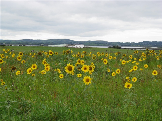
Ballyquintin Farm, Port Kelly Trail

Down

A grassland walk situated at the very tip of the Ards Peninsula at the mouth of Strangford Lough. This walk passes through farmland, rocky shore and beach owned and managed by the National Trust and National Nature Reserve owned and managed by the Environment and Heritage Service. Take in views across Strangford Lough to Killard Point and across the Irish sea to The Isle of Man on a clear day. The rich coastal grassland here includes some sensitive and rare flowers including orchids and wild – dwarfed Burnett rose. Bird Watchers: Look out for the bird species include skylarks, linnets, peregrine falcons, buzzards, kestrals and Brent geese.

DISTANCE

0.8 miles

ROUTE TYPE

Loop

OS MAP

21

GRID REFERENCE

J623465

COUNTY

Down

NEAREST TOWN

Portaferry

LANDSCAPE

Coastal

LEVEL OF DIFFICULTY

Easy

TERRAIN

Off road paths, quiet rural road

ON/OFF PUBLIC ROAD

null

DIFFICULTY

null

TRAIL INFORMATION

From the car park, set off down the hill, following the signs to Port Kelly. Crossing through the stile on your left follow the path through the field to the next stile. Here turn right and follow the trail down to the shore. After exploring Port Kelly for a while, retrace your steps for a short distance and carry on past the previous stile following the signs in the direction of Bar Hall Bay. This will eventually lead you down a grassy lane and through a field and two more stiles before coming out onto the shore at Bar Hall Bay. Turn right and follow this path northwards along the shore looking out for seals basking on the rocks as you go. When reaching the road, turn right. Taking the first turning on your right follow the access road along which you arrived back to the car park.

GETTING TO THE START

Take the coastal road south of Portaferry. After about 5km National Trust signage directs to Ballyquintin Farm and Nature Reserve on the right.
  • Point of Interest
    Port Kelly, Bar Hall Bay, Coastal views and wildlife
  • Facilities
    Car park. The nearby towns of Portaferry and Strangford have several popular pubs, restaurants and cafes. The following facilities are available for users with limited mobility: – Disabled parking
  • Dog Policy
    Must be kept on a lead.
  • Getting to the Start
    Take the coastal road south of Portaferry. After about 5km National Trust signage directs to Ballyquintin Farm and Nature Reserve on the right.
  • Public Transport
  • Level of Difficulty
    Easy TRAIL GRADE DISCLAIMER

    The trail grades shown on OutmoreNI.com and WalkNI.com are based on desk-based assessments of available trail information. The categories—Easy, Moderate, Strenuous, and Very Strenuous—follow the Sustainable Trails Development Guide grading system.

    These grades are provided as a general guide to help users choose trails that may be suitable for them. They are not a substitute for official, on-site grading or safety information provided by the relevant land manager, which may differ from the information on these websites.

    Outdoor activities involve inherent risks, including the risk of injury, death, property damage, and other hazards. By using information from OutmoreNI.com and WalkNI.com, you acknowledge that you do so at your own risk. OutmoreNI.com and WalkNI.com accept no responsibility or liability for any loss, injury, or damage arising from the use of this information.

    Conditions on trails can change, and the actual environment may differ from what is described online. Users should always exercise their own judgment, take appropriate precautions, and remain responsible for their own safety and conduct at all times.

    All information provided on OutmoreNI.com and WalkNI.com is intended as a guide only and should be used alongside your own experience, awareness, and careful decision-making.

    Relatively flat or gently rolling trails with a mostly smooth surface. You might come across some obstacles like bridges, gates and steps.

    Normal clothing and footwear can be worn.

GALLERY

DOWNLOADS & PUBLICATIONS


Subscribe to our Newsletter

Subscribe and be the first to hear about new outdoor trails and places or find inspiration to help you plan days out.

No spam. Easy unsubscribe links are provided in every email.

Keep in touch with us

This website has been produced by

Privacy Policy | Cookie Policy | Disclaimer

© 2026 | Outmore NI. All rights reserved. Website designed & developed by SugarProjects