3.2 miles
Linear
Easy
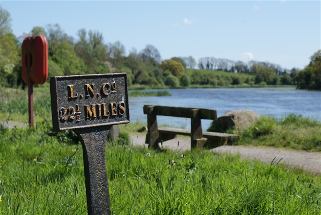
Broad Water
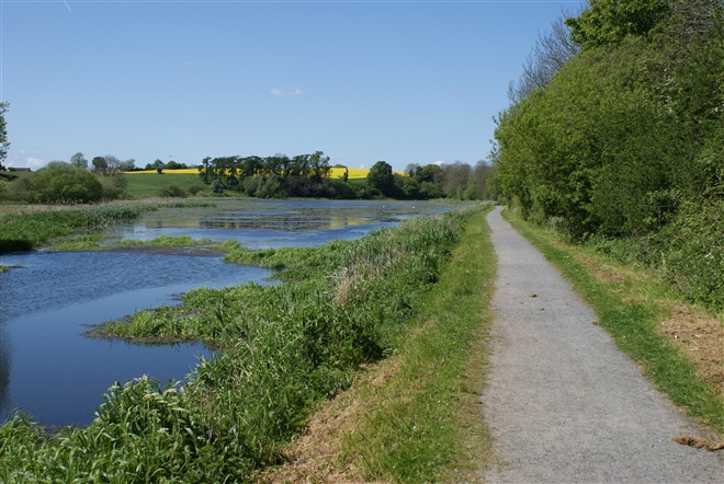
The Broad Water is a 3 mile (4.8km) towpath walk between Moira Railway Station and Aghalee and takes you along the route of the original Lagan Canal through Soldierstown. Keep an eye out for the large variety of breeding and wintering wildfowl.
Since the canal was officially abandoned in 1954 the banks have become overgrown and an array of colour is provided by a variety of trees, shrubs and wild flowers. Moira is unique as being the only town in Ireland to straddle two counties, County Down and County Armagh
The Broad Water is a man made feature, built in a natural valley in order to retain a sufficient head of water to accommodate the navigation. Take a seat and enjoy the sights and sounds of nature, set against the background of a thin belt of mature woodland!
TRAIL INFORMATION
Begin walking from the entrance located in the car park of Moira Railway Station. Passing under the bridge that carries the railway line which was built in 1833, stop to have a look at the unusual “skew brickwork” used to add strength to the bridge and how the strain of the tow rope cut notches in the iron guard at the foot of the bridge. Further along after passing the car park and picnic tables at Soldierstown Car Park you come to a large expanse of water, known as the Broad Water. Look out for the Soldierstown Church up on your left, where the engineer responsible for the Lisburn-Lough Neagh section of the canal, Richard Owen, was buried in 1830. On reaching the top end of the main Broad Water you will see the former bank-ranger’s house however this is now privately owned. The final part of the walk will take you into the Village of Aghalee.
For those who wish to continue their journey towards Lisburn, then you can either take the train from Moira Railway Station or simply follow small country back roads, joining the towpath of the Lagan Valley Regional Park at Union Locks, Blaris Road, Lisburn.
GETTING TO THE START
- Point of Interest Soldierstown Church & Graveyard
- Facilities Car parking available at Soldierstown. Refreshments available in Moira. The following facilities are available for users with limited mobility: – Disabled parking.
- Dog Policy Dogs must be kept under close control
- Accessibility Information
Accessibility Grade: Grade 4 Terrain: Flat towpath Toilet Facility: No Signage: No - Getting to the Start A pedestrian entrance to the Broad Water is available from the car of Moira Railway Station, Station Rd, Moira. A car park, picnic tables and link to the towpath are located at Soldierstown Car Park on the Soldierstown Road approximately midway between the villages of Moira and Aghalee. In addition the route can also be accessed in Aghalee Village from Soldierstown Road.
- Public Transport Translink – journeyplanner.translink.co.uk
- Level of Difficulty
 Easy TRAIL GRADE DISCLAIMER
 The trail grades shown on OutmoreNI.com and WalkNI.com are based on desk-based assessments of available trail information. The categories—Easy, Moderate, Strenuous, and Very Strenuous—follow the Sustainable Trails Development Guide grading system.
These grades are provided as a general guide to help users choose trails that may be suitable for them. They are not a substitute for official, on-site grading or safety information provided by the relevant land manager, which may differ from the information on these websites.
Outdoor activities involve inherent risks, including the risk of injury, death, property damage, and other hazards. By using information from OutmoreNI.com and WalkNI.com, you acknowledge that you do so at your own risk. OutmoreNI.com and WalkNI.com accept no responsibility or liability for any loss, injury, or damage arising from the use of this information.
Conditions on trails can change, and the actual environment may differ from what is described online. Users should always exercise their own judgment, take appropriate precautions, and remain responsible for their own safety and conduct at all times.
All information provided on OutmoreNI.com and WalkNI.com is intended as a guide only and should be used alongside your own experience, awareness, and careful decision-making.
Relatively flat or gently rolling trails with a mostly smooth surface. You might come across some obstacles like bridges, gates and steps.
Normal clothing and footwear can be worn.