2.4 miles
Loop
Moderate
Castle Caldwell Forest; Rossergole Point Walk
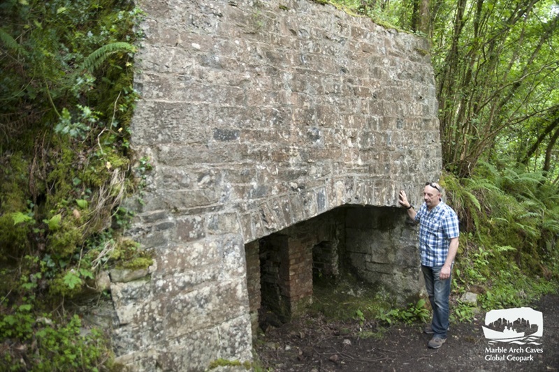
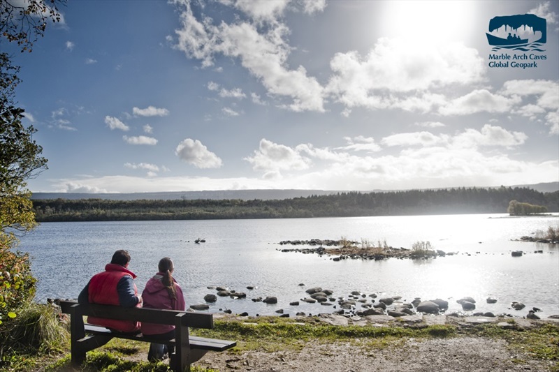
Rossergole Point Walk is part of the Marble Arch Caves Global Geopark. The walk takes in man-made and natural wonders, including a lime-kiln which hints at the association of the Caldwell estate with the nearby Belleek Pottery, a half-moon limestone bench along the shoreline and the eerie ruins of Castle Caldwell.
TRAIL INFORMATION
Following the lake shore through wonderful mixed woodland comprising of ash, beech, oak, and holly. This popular path takes in the remnants of the estate’s castle, forts, defence walls, jetties and lime kiln. Walkers who take time to explore the area will find the industrial-scale lime kiln highlighting the importance of the local limestone, once frequently fired in the kiln to produce quicklime, and taken by barge to the nearby town of Belleek. Another interesting feature which may be found at the eastern tip of the peninsula, are the walls of the old strategic defence fort of Rossergole Point. This fortification no doubt played a vital role in protecting and controlling trade along this route. Today the old ruins offer walkers a vantage point for breathtaking views over Lower Lough Erne. Travelling onwards, the southern shore of the peninsula forms part of the Lower Lough Erne Nature Reserve, managed by the Royal Society for the Protection of Birds (RSPB). The varied habitats within the forest and along this shoreline have attracted many types of birds, including many species of water birds, and songbirds. Continuing onward you will shortly join a forest track where its course carries you through attractive stands of ash trees and into denser forest before taking in the remnants of Castle Caldwell, a prominent feature within the woodland setting. This walk is situated in a working forest and may be temporarily diverted or closed while trees are being harvested so please comply with any safety signage. All Forest Service woodlands are sustainably managed and certified to international standards that demonstrate good environmental, social and economic principles.
GETTING TO THE START
- Point of Interest Castle Caldwell ruins, Lime Kiln
- Facilities Car parking & picnic facilities. Refreshments available in Belleek village – approximately 8km away
- Getting to the Start Turn off Kesh – Belleek A47 road about 8km from Belleek into Castle Caldwell Forest. Turn is well signposted. Pass between support walls of old railway bridge, then turn left and later left again into car park.
- Public Transport Translink – journeyplanner.translink.co.uk
- Level of Difficulty
 Moderate TRAIL GRADE DISCLAIMER
 The trail grades shown on OutmoreNI.com and WalkNI.com are based on desk-based assessments of available trail information. The categories—Easy, Moderate, Strenuous, and Very Strenuous—follow the Sustainable Trails Development Guide grading system.
These grades are provided as a general guide to help users choose trails that may be suitable for them. They are not a substitute for official, on-site grading or safety information provided by the relevant land manager, which may differ from the information on these websites.
Outdoor activities involve inherent risks, including the risk of injury, death, property damage, and other hazards. By using information from OutmoreNI.com and WalkNI.com, you acknowledge that you do so at your own risk. OutmoreNI.com and WalkNI.com accept no responsibility or liability for any loss, injury, or damage arising from the use of this information.
Conditions on trails can change, and the actual environment may differ from what is described online. Users should always exercise their own judgment, take appropriate precautions, and remain responsible for their own safety and conduct at all times.
All information provided on OutmoreNI.com and WalkNI.com is intended as a guide only and should be used alongside your own experience, awareness, and careful decision-making.
Moderately challenging trails of varying widths with some short, steep climbs and descents. The surface may vary throughout, be slippery and uneven in places. Expect there to be obstacles like exposed roots, narrow gates, stiles and long sets of steps.
Outdoor clothing and sturdy footwear are recommended.