1.2 miles
Loop
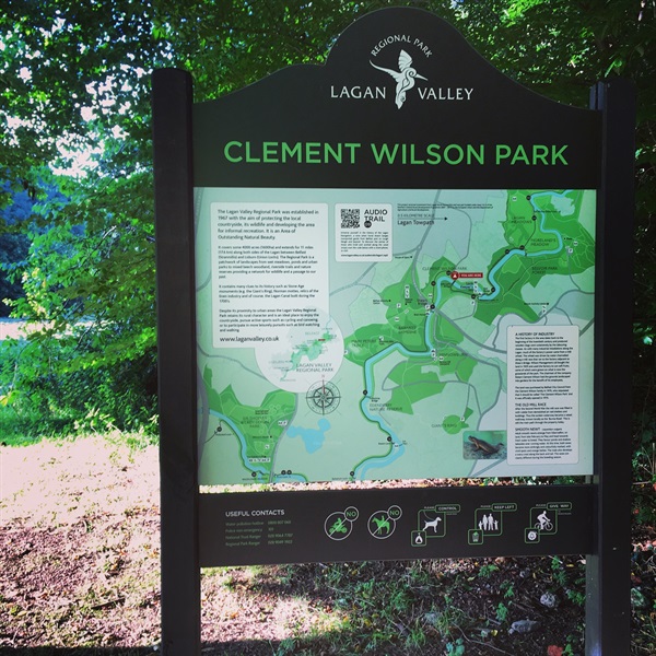
Clement Wilson Park
This route is through parkland in Lagan Valley Regional Park. It runs alongside the River Lagan and returns via the Lagan Towpath. It has been designed for use by disabled users. A section of the National Cycle Network Route 9 also runs through the park.
TRAIL INFORMATION
Cross the old Shaw’s Bridge and descend the ramps on your left. Turn right at the bottom pass under the modern A55 road bridge and follow the towpath, firstly alongside the river and then by the disused canal. The canal can be crossed using the humpback bridge or the flat wooden bridge. Both lead to the front of the lock-keeper’s cottage. The Lock Keepers Inn has been open at this location since 2007 and provides lunches, teas, coffees etc. Turn left following the path to Newforge Lane via the wooden bridge over the River Lagan. This path is also part of the National Cycle Network route and is shared with bicycles.
There may be traffic on Newforge Lane. Follow the footpath for a short distance to reach Clement Wilson Park. The raised surfaced path is known locally as the Burma Road. This was a mill race which was filled in with rubble from bomb damaged buildings after WW2. It leads back to the car park, passing under the new road bridge beside Shaw’s Bridge.
GETTING TO THE START
- Point of Interest Lockkeepers Cottage, Shaws Bridge, Lagan Canal
- Facilities Malone House: Cafe, Toilets and Information - opening hours applyLock Keepers Inn: Closed Mondays. Open Tuesday-Friday 8.30 am-5.00 pm, Saturday-Sunday 8.00 am-6.00 pm. The following facilities are available for users with limited mobility: – Café (wheelchair accessible) – (Lock Keepers Inn – open tues-fri 8.30am – 5pm, sat-sun 8am – 6pm, closed mon) – Disabled toilets – (Lock Keepers Inn) – Disabled parking – (Shaws Bridge).
- Accessibility Information
Accessibility Grade: Grade 3 Terrain: Surfaced tarmac paths Toilet Facility: No Signage: No - Getting to the Start Car parking at Shaw's Bridge - car park off the A55 Outer Ring.
- Public Transport Translink – journeyplanner.translink.co.uk