2.6 miles
Loop
Strenuous
Cloughmore Trail via Fiddler's Green
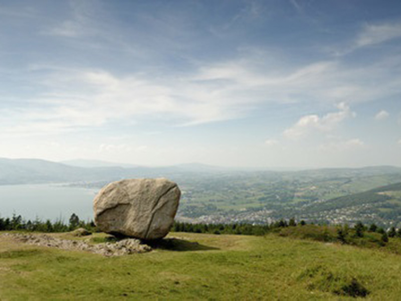
Kilbroney Park, Rostrevor, is situated in a stunning location, where mountain, sea and valley create a scenic wonderland. Overlooking Carlingford Lough, these 97 acres of beautiful parkland nestle within the shadow of Slieve Martin and the mountains of Mourne. According to local folklore, the Big Stone was thrown across the lough by Finn McCool during a fight with a giant rival. Follow this trail to the “Chloch Mhór” (Irish for big stone) to enjoy panoramic views across Carlingford Lough and the surrounding landscape.
TRAIL INFORMATION
This walk starts in the upper car park (way-marker no. 1). Follow the trail uphill until you reach the big stone (way-marker no.3). Enjoy the views from this great vantage point before following the way-markers downhill as you make your way to a further viewpoint area before reaching the Fiddler’s Green.
The latter, small clearing is located at the southern end of the ancient oakwood and was once a focal point for local entertainment. This custom is maintained in the annual Fiddler’s Green traditional music festival, which uses the green as well as other venues across the village.
Continue on the trail through the ancient oakwood until you rejoin the main road which leads up past the main car park/café/reception area (way-marker no. 15). Follow the way-markers as you begin your ascent towards the upper car park, completing this circular route walk. It is also an option to start and finish from the main car park (way-marker no 15) bearing in mind that when you reach the upper car park and pass way-marker no.22 that the next way-marker will be 1.
GETTING TO THE START
- Point of Interest Cloughmore (or the ‘Big Stone’), Fiddler’s Green, ancient Oakwood, natural heritage
- Facilities Please note parking fees apply. Facilities within Kilbroney Park include: Kilbroney Tree Trail, Narnia Trail, Fairy Glen, Mountain Bike Trails, Rostrevor Mountain Bike Centre, Caravan Park, Café, Toilets, Car Park, Children’s Play Park, Adult outdoor gym, ancient Oakwood In addition, there is a wide range of restaurants/cafes/shops in Rostrevor to suit all tastes.
- Dog Policy Must be kept on a lead.
- Getting to the Start Kilbroney Park is located on the Shore Road (A2) between Rostrevor and Kilkeel. Numbered way-marking posts are in place with way-marker no. 1 being at the upper car park. Alternatively, pedestrian access from the village is via the Fairy Glen entrance to the park.
- Level of Difficulty
 Strenuous TRAIL GRADE DISCLAIMER
 The trail grades shown on OutmoreNI.com and WalkNI.com are based on desk-based assessments of available trail information. The categories—Easy, Moderate, Strenuous, and Very Strenuous—follow the Sustainable Trails Development Guide grading system.
These grades are provided as a general guide to help users choose trails that may be suitable for them. They are not a substitute for official, on-site grading or safety information provided by the relevant land manager, which may differ from the information on these websites.
Outdoor activities involve inherent risks, including the risk of injury, death, property damage, and other hazards. By using information from OutmoreNI.com and WalkNI.com, you acknowledge that you do so at your own risk. OutmoreNI.com and WalkNI.com accept no responsibility or liability for any loss, injury, or damage arising from the use of this information.
Conditions on trails can change, and the actual environment may differ from what is described online. Users should always exercise their own judgment, take appropriate precautions, and remain responsible for their own safety and conduct at all times.
All information provided on OutmoreNI.com and WalkNI.com is intended as a guide only and should be used alongside your own experience, awareness, and careful decision-making.
Physically demanding, narrow trails with steep climbs and descents over short and long distances. Expect the surface to be uneven and changeable throughout with natural surfaces like grass, exposed rock and trodden earth. The surface may change suddenly and be unstable in places. There will be slippery sections when wet and large, frequent obstacles like exposed roots, large boulders, overgrown sections, uneven stiles and long stretches of uneven steps.
Outdoor clothing and sturdy footwear are recommended.