8 miles
Linear
Strenuous
Comber Greenway
This walk leads from the centre of Belfast to the town of Comber along the line of the former railway.
This route provides a tranquil green corridor through East Belfast and ending passing through a rural landscape into Comber.
TRAIL INFORMATION
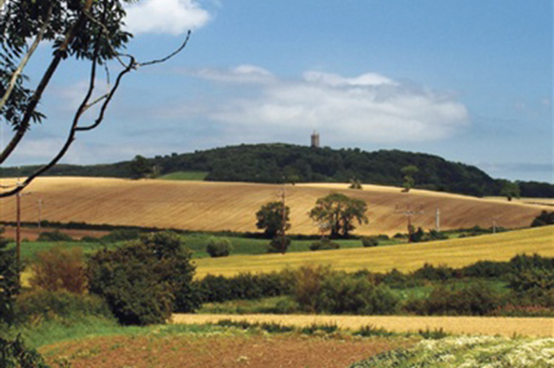
The Comber Greenway is a 7 mile traffic free section of the National Cycle Network developed by Sustrans along the old Belfast to Comber railway line. The path was completed in November 2008 and provides a tranquil green corridor all the way from Comber to the heart of East Belfast with views along the route of Stormont and Scrabo Tower. The walking and cycling route provides local people with a traffic free environment for leisure walking and cycling and offers commuting cyclists a direct and traffic-free route from Comber to Belfast city centre.
The traffic free route begins at Dee Street in East Belfast and passes by the CS Lewis statue at the Holywood Arches, along the Bloomfield Walkway to Sandown Road where it continues past the Police Service NI headquarters to a newly installed toucan crossing at the Knock Road.
From here it travels up to the Kings Road and onwards to Abbey Road, through Tullycarnet and Ardcarn to East Link Road in Dundonald.
The greenway continues through a wetland area emerging at the Comber Road, Dundonald where a toucan crossing has been installed. The route continues from Comber Road, Dundonald past the Billy Neill Centre for Soccer Excellence where the former railway line runs near to the Enler River. Walkers and cyclists can cross the River Enler and farm lanes using a series of reinstated bridges before reaching the final destination at the Belfast Road, Comber.
TRAIL INFORMATION
The Comber Greenway is a 7 mile traffic free section of the National Cycle Network developed by Sustrans along the old Belfast to Comber railway line. The path was completed in November 2008 and provides a tranquil green corridor all the way from Comber to the heart of East Belfast with views along the route of Stormont and Scrabo Tower. The walking and cycling route provides local people with a traffic free environment for leisure walking and cycling and offers commuting cyclists a direct and traffic-free route from Comber to Belfast city centre.
The traffic free route begins at Dee Street in East Belfast and passes by the CS Lewis statue at the Holywood Arches, along the Bloomfield Walkway to Sandown Road where it continues past the Police Service NI headquarters to a newly installed toucan crossing at the Knock Road.
From here it travels up to the Kings Road and onwards to Abbey Road, through Tullycarnet and Ardcarn to East Link Road in Dundonald.
The greenway continues through a wetland area emerging at the Comber Road, Dundonald where a toucan crossing has been installed. The route continues from Comber Road, Dundonald past the Billy Neill Centre for Soccer Excellence where the former railway line runs near to the Enler River. Walkers and cyclists can cross the River Enler and farm lanes using a series of reinstated bridges before reaching the final destination at the Belfast Road, Comber.
GETTING TO THE START
- Point of Interest Views of Harland & Wolf, Stormont, Cs Lewis Statue, Scrabo Tower
- Facilities Facilities can be found at Ballyhackamore, Tullycarnet, Dundonald and Comber.
- Dog Policy Dogs must be kept under control at all times
- Getting to the Start Start is at Dee Street off Newtownards Road.
- Public Transport Translink – journeyplanner.translink.co.uk
- Level of Difficulty
 Strenuous TRAIL GRADE DISCLAIMER
 The trail grades shown on OutmoreNI.com and WalkNI.com are based on desk-based assessments of available trail information. The categories—Easy, Moderate, Strenuous, and Very Strenuous—follow the Sustainable Trails Development Guide grading system.
These grades are provided as a general guide to help users choose trails that may be suitable for them. They are not a substitute for official, on-site grading or safety information provided by the relevant land manager, which may differ from the information on these websites.
Outdoor activities involve inherent risks, including the risk of injury, death, property damage, and other hazards. By using information from OutmoreNI.com and WalkNI.com, you acknowledge that you do so at your own risk. OutmoreNI.com and WalkNI.com accept no responsibility or liability for any loss, injury, or damage arising from the use of this information.
Conditions on trails can change, and the actual environment may differ from what is described online. Users should always exercise their own judgment, take appropriate precautions, and remain responsible for their own safety and conduct at all times.
All information provided on OutmoreNI.com and WalkNI.com is intended as a guide only and should be used alongside your own experience, awareness, and careful decision-making.
Physically demanding, narrow trails with steep climbs and descents over short and long distances. Expect the surface to be uneven and changeable throughout with natural surfaces like grass, exposed rock and trodden earth. The surface may change suddenly and be unstable in places. There will be slippery sections when wet and large, frequent obstacles like exposed roots, large boulders, overgrown sections, uneven stiles and long stretches of uneven steps.
Outdoor clothing and sturdy footwear are recommended.