4.9 miles
Loop
Dromara Bridleways Walk
.
A trip through lanes in the Slieve Croob area of the Mourne Area of Outstanding Natural Beauty in the countryside between Dromara and Ballynahinch. This walk follows 2 public rights of way and narrow country roads in the rolling Dromara Hills. A walk for clear weather when the views can be enjoyed.
Formerly within the former Banbridge District Council area as from April 1 2015 the route falls within the new Newry Mourne & Down district council area
TRAIL INFORMATION
Please note that there is Harvesting happening on site between June and August and again between Setptember and October. See the PDF Download for the affected areas.
The suggested walk starts at the main car park at Drumkeeragh Forest (though you can shorten it if preferred). Drumkeeragh is a mixed conifer forest managed by Forest Service located off the Drumnaquoile Road between Dromara and Castlewellan.
Park at Drumkeeragh Forest Park car park and follow the forest trail for a short distance from the car park towards the sw corner of the forest walking parallel with the Drumnaquoile Road. Leave the forest at the access barrier/lay-by off the Drumnaquoile Road (alternatively park here in the first instance). Turn right into the Drumnaquoile/Castlewellan Road and walk down the hill being alert for traffic and exercising common sense on these narrow country roads.
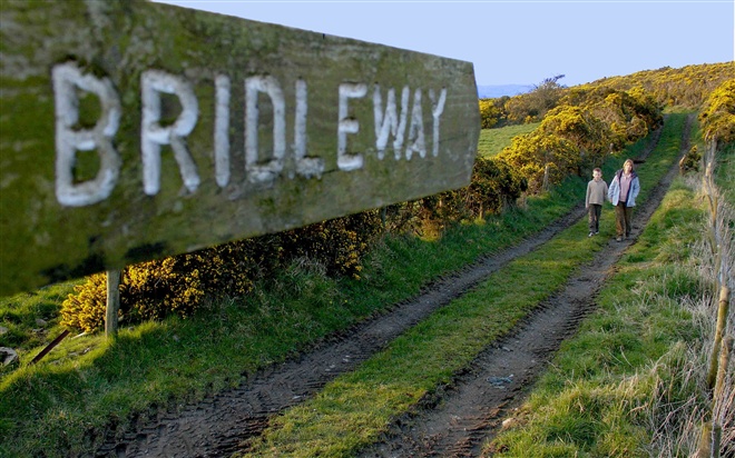
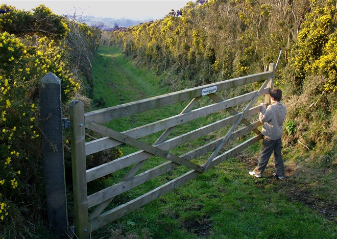
After approx. 2 miles look out for the Gaelic Football ground on R, a short distance past this on the R is a lane marked with a bridleway sign (this is Darby's Loanin'). Turn R into this lane and follow it, continuing through a farmyard until you reach the Moneynabane Road. There are a series of wooden equestrian gates across the route. The path can be very muddy and wet at times and appropriate footwear is recommended.
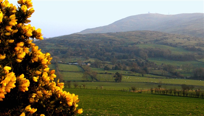
On meeting the Moneynabane Road turn L and continue along this road for approx. 0.5 mile, enjoying the views of Slieve Croob on the R. The River Lagan, on which the city of Belfast is built, rises as a tiny stream on the slopes of Slieve Croob. Look out for a wooden bridleway sign on R and follow this lane (Glen Loanin') past the farmyward to meet the Drumboy Road. The lane has an uenven surface and can be muddy and wet at times. Appropriate footwear recommended. It gives great views across the surrounding countryside. Turn R into the road and walk towards the mountain.
At its junction with the Drumnaquoile/Castlewellan Road take a L and retrace your steps to return to the starting point.
TRAIL INFORMATION
Please note that there is Harvesting happening on site between June and August and again between Setptember and October. See the PDF Download for the affected areas.
The suggested walk starts at the main car park at Drumkeeragh Forest (though you can shorten it if preferred). Drumkeeragh is a mixed conifer forest managed by Forest Service located off the Drumnaquoile Road between Dromara and Castlewellan.
Park at Drumkeeragh Forest Park car park and follow the forest trail for a short distance from the car park towards the sw corner of the forest walking parallel with the Drumnaquoile Road. Leave the forest at the access barrier/lay-by off the Drumnaquoile Road (alternatively park here in the first instance). Turn right into the Drumnaquoile/Castlewellan Road and walk down the hill being alert for traffic and exercising common sense on these narrow country roads.
After approx. 2 miles look out for the Gaelic Football ground on R, a short distance past this on the R is a lane marked with a bridleway sign (this is Darby's Loanin'). Turn R into this lane and follow it, continuing through a farmyard until you reach the Moneynabane Road. There are a series of wooden equestrian gates across the route. The path can be very muddy and wet at times and appropriate footwear is recommended.
On meeting the Moneynabane Road turn L and continue along this road for approx. 0.5 mile, enjoying the views of Slieve Croob on the R. The River Lagan, on which the city of Belfast is built, rises as a tiny stream on the slopes of Slieve Croob. Look out for a wooden bridleway sign on R and follow this lane (Glen Loanin') past the farmyward to meet the Drumboy Road. The lane has an uenven surface and can be muddy and wet at times. Appropriate footwear recommended. It gives great views across the surrounding countryside. Turn R into the road and walk towards the mountain.
At its junction with the Drumnaquoile/Castlewellan Road take a L and retrace your steps to return to the starting point.
GETTING TO THE START
- Point of Interest Great views of Slieve Croob - Source of the River Lagan
- Facilities Free parking at Drunkeeragh Forest. Surrounding Area (not on walk route). Photos of souterrian and Legananny Dolmen are included in the gallery. Slieve Croob Transmitter Road Walk from Dree Hill Car Park (picnic and viewpoint site) - see link to Slieve Croob attractions map for location of this and following: Finnis Souterrain, Carrigagh Road (near Finnis/Massford) - hidden gem - scheduled historic monument opened to the public by Banbridge District Council in 2003. Underground structure dating from c. 9th century - lit by solar lighting. Narrow space - requires bending and stooping to enter. Normally open at all times but prone to flooding after periods of heavy rain so may not always be accessible. Legananny Dolmen - state care monument - one of the most photographed dolmens in Ireland, located off Dolmen Road. 4 miles (6.4 km) south of Dromara & 5 miles (8 km) n.w. of Castlewellan - tripod portal tomb - has been standing here for around 4000 years.
- Dog Policy Dogs should be under close control at all times.
- Getting to the Start The suggested walk starts at the main car park in Drumkeeragh Forest (though you can shorten it if preferred). The forest is located on the slopes of Slieve Croob, off the Drumnquoile/Castlewellan Road - between Dromara and Castlewellan (follow the Castlewellan Road out of Dromara for approx. 3.5 miles). It is located approx. 7 miles sw of Ballynahinch - w. of McAuley's Lake. Leaving Ballynahinch towards Newcastle along the A24 take the road signed for Castlewellan due south thru Spa and along the shore of McAuley's Lake. At the next sign for Castlewellan, near the lake turn right towards Magherahamlet Church and take the road on the left at the church (Drumgavlin Road) continue thru x-road and at next staggered x-road turn L and immediately R (onto Mountain Road) for approx. 2.4 miles along this scenic but narrow countryroad. At junction with Drumnaquoile Road (at small country shop) take a right (N) onto the Drumnaquoile Road for appox. 0.9 mile and you will see the forest on your left. If main forest access is closed drive by and park at small lay-by further down road.
- Public Transport Translink – journeyplanner.translink.co.uk