1.6 miles
Linear
Dundrum Coastal Path
The Dundrum Coastal Path runs along a 2.5 km stretch of disused railway line on the western shore of Dundrum Inner Bay. The path forms part of the Lecale Way and is popular with walkers and birdwatchers alike. The path itself is of considerable nature conservation interest with a variety of semi-natural habitats along its length including herb-rich grassland, marginal scrub and scrub-woodland, marshy tall herb stands, brackish pools, and a narrow fringe of saltmarsh.
TRAIL INFORMATION
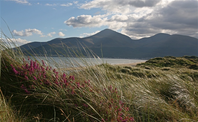
The trail begins in the small National Trust car park accessed by turning right off the main A2 a few hundred metres north of Dundrum village. Looking east at high tide across the waters of Dundrum inner Bay and at low tide across its estuarine sands and muds, the Dundrum Coastal Path offers vistas of exceptional beauty. The gentle shelving shoreline of Dundrum Inner Bay merges with the shingle, sandy spit and dunes of Murlough. Across the bay lie the fertile plains of Lecale, while behind the village on the summit of a rocky hill, stands one of Northern Ireland’s most evocative medieval ruins; Dundrum Castle. To the south of the Coastal path is Widow’s Row, a small group of cottages built by public subscription to house the wives and children of the Dundrum fishermen who lost their lives in the fishing disaster of 1843.
Turn left and continue along the trail following the way markers as necessary. Dundrum Inner Bay is of very high interest for both its marine life and is part of the Murlough Special Area of Conservation. It regularly holds significant numbers of wildfowl and waders throughout the winter. The birds come to the estuary because of the relatively mild climate and abundance of food found on the mudflats. Green Island, a small low-lying island in Dundrum Inner Bay, is one of the major high tide roosts within the Inner Bay. Species include oystercatcher, lapwing, redshank and curlew, and during the winter small numbers of black-tailed godwit, turnstone and grey plover are present.
The path follows the old railway line and opposite Ardilea Bridge an artificial embankment carries the track across the Inner Bay. The trail ends 400 meters beyond the Ardilea Bridge. Walkers can retrace their steps back to the car park in Dundrum.
TRAIL INFORMATION
The trail begins in the small National Trust car park accessed by turning right off the main A2 a few hundred metres north of Dundrum village. Looking east at high tide across the waters of Dundrum inner Bay and at low tide across its estuarine sands and muds, the Dundrum Coastal Path offers vistas of exceptional beauty. The gentle shelving shoreline of Dundrum Inner Bay merges with the shingle, sandy spit and dunes of Murlough. Across the bay lie the fertile plains of Lecale, while behind the village on the summit of a rocky hill, stands one of Northern Ireland’s most evocative medieval ruins; Dundrum Castle. To the south of the Coastal path is Widow’s Row, a small group of cottages built by public subscription to house the wives and children of the Dundrum fishermen who lost their lives in the fishing disaster of 1843.
Turn left and continue along the trail following the way markers as necessary. Dundrum Inner Bay is of very high interest for both its marine life and is part of the Murlough Special Area of Conservation. It regularly holds significant numbers of wildfowl and waders throughout the winter. The birds come to the estuary because of the relatively mild climate and abundance of food found on the mudflats. Green Island, a small low-lying island in Dundrum Inner Bay, is one of the major high tide roosts within the Inner Bay. Species include oystercatcher, lapwing, redshank and curlew, and during the winter small numbers of black-tailed godwit, turnstone and grey plover are present.
The path follows the old railway line and opposite Ardilea Bridge an artificial embankment carries the track across the Inner Bay. The trail ends 400 meters beyond the Ardilea Bridge. Walkers can retrace their steps back to the car park in Dundrum.
GETTING TO THE START
- Point of Interest Birdlife, varied habitats, views across the bay
- Facilities Carpark, bike racks, picnic table and holiday cottage. The following facilities are available for users with limited mobility: – Disabled parking
- Dog Policy Dogs must be kept on leads
- Accessibility Information
Accessibility Grade: Grade 3 Terrain: Grassland Toilet Facility: No Signage: No - Getting to the Start The trail begins in the small National Trust car park accessed by turning right off the main A2 a few hundred metres north of Dundrum village
- Public Transport Translink – journeyplanner.translink.co.uk