3.5 miles
Linear

Very Strenuous
Glen River

This walk follows a popular route leading to the summit of Slieve Donard (850m), Northern Ireland highest mountain. From Newcastle it ascends through the woods along the Glen River and climbs 3km to the head of the river valley, high on the slopes below Slieve Donard ad Slieve Commedagh (765m). From here the path continues to the Saddle (the col between Donard and Commedagh) from which point either summit can be reached.
TRAIL INFORMATION
Begin in Donard Park, walk to the rear of the car park, keeping to the right of the Glen River to enter Donard Wood (300m). Once in the wood the path ascends for 150m until it meets Donard Bridge.
Cross the bridge onto the rivers left side. After 400m arrive a second bridge. Recross the river into its right hand side and continue upstream
After a further 400m a third bridge is reached. Remain on the right bank and continue 150m to a stile marking the beginning of the open mountainside. Follow obvious track above course of the Glen River for 2km.
Perched on the opposite bank of the river is an igloo-like stone structure. This was an ‘ice house’ built by the Annesley Family (former owners of Donard Park) and functioned as a primitive fridge. Below the ice house a tributary joins the Glen River after cascading down a dark rocky cleft (known as the Black Stairs) on the side of the nearby Thomas’s Mountain. .
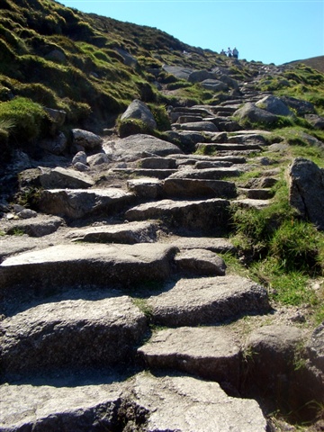
Cross the river at a narrow point. From here the path climbs more steeply to reach a saddle (and the Mourne Wall) after 500m. This has recently undergone extensive path repair by stone pitching. Please keep to the path.
From the saddle, both Donard and Commedagh can be reached by following the Mourne Wall uphill to either peak.
Slieve Donard dominates the whole of south –east Ulster. On a clear day the view from its summit extends beyond the sweeping arc of Dundrum bay as far as the Mountains of southwest Scotland, northwest England and the Isle of Man and Snowdonia in Wales. The mountain is named after Domangard, a local chieftain who became a disciple of St Patrick and is believed to have built a stone prayer cell on the summit.
Next in stature to Donard, Slieve Commedagh lacks its sister’s peak commanding coastal position, but offers a magnificent view south over the wilderness of the Annalong Valley and a panorama across the entire range of Mourne peaks.
You have now reached the highest point of the walk.
After pausing and enjoying the view, turn and retrace your steps back downhill to Donard Car Park.
Please be aware - Although, there are numerous walking routes in the Mournes, the majority of these popular walks are not formally designated public rights of way. Most routes have developed over time due to traditional use. Below 600 feet (180m) most land is privately owned and is farmed or grazed. Many of the traditional access routes cross this land or pass along farm lanes and quarry tracks. Walkers are advised to respect that they may be walking on private land and are encouraged to make themselves aware of and adhere to the principles of 'Leave No Trace' - www.leavenotraceireland.org"
Please remember that much of the land you will cross is private property and access is only available through the goodwill of the landowners. Although some areas of the countryside have been traditionally used for recreation, the public have no general rights to access such land and are only walking with the tolerance of the landowner.
TRAIL INFORMATION
Begin in Donard Park, walk to the rear of the car park, keeping to the right of the Glen River to enter Donard Wood (300m). Once in the wood the path ascends for 150m until it meets Donard Bridge.
Cross the bridge onto the rivers left side. After 400m arrive a second bridge. Recross the river into its right hand side and continue upstream
After a further 400m a third bridge is reached. Remain on the right bank and continue 150m to a stile marking the beginning of the open mountainside. Follow obvious track above course of the Glen River for 2km.
Perched on the opposite bank of the river is an igloo-like stone structure. This was an ‘ice house’ built by the Annesley Family (former owners of Donard Park) and functioned as a primitive fridge. Below the ice house a tributary joins the Glen River after cascading down a dark rocky cleft (known as the Black Stairs) on the side of the nearby Thomas’s Mountain. .
Cross the river at a narrow point. From here the path climbs more steeply to reach a saddle (and the Mourne Wall) after 500m. This has recently undergone extensive path repair by stone pitching. Please keep to the path.
From the saddle, both Donard and Commedagh can be reached by following the Mourne Wall uphill to either peak.
Slieve Donard dominates the whole of south –east Ulster. On a clear day the view from its summit extends beyond the sweeping arc of Dundrum bay as far as the Mountains of southwest Scotland, northwest England and the Isle of Man and Snowdonia in Wales. The mountain is named after Domangard, a local chieftain who became a disciple of St Patrick and is believed to have built a stone prayer cell on the summit.
Next in stature to Donard, Slieve Commedagh lacks its sister’s peak commanding coastal position, but offers a magnificent view south over the wilderness of the Annalong Valley and a panorama across the entire range of Mourne peaks.
You have now reached the highest point of the walk.
After pausing and enjoying the view, turn and retrace your steps back downhill to Donard Car Park.
Please be aware - Although, there are numerous walking routes in the Mournes, the majority of these popular walks are not formally designated public rights of way. Most routes have developed over time due to traditional use. Below 600 feet (180m) most land is privately owned and is farmed or grazed. Many of the traditional access routes cross this land or pass along farm lanes and quarry tracks. Walkers are advised to respect that they may be walking on private land and are encouraged to make themselves aware of and adhere to the principles of 'Leave No Trace' - www.leavenotraceireland.org"
Please remember that much of the land you will cross is private property and access is only available through the goodwill of the landowners. Although some areas of the countryside have been traditionally used for recreation, the public have no general rights to access such land and are only walking with the tolerance of the landowner.
GETTING TO THE START
- Point of Interest Slieve Donard (N. Ireland's highest mountain), Glen River, Ice House
- Facilities Car park has toilets. There are a range of places to eat and shop in the town of Newcastle. The following facilities are available for users with limited mobility: – Disabled parking – Disabled toilets
- Dog Policy Dogs must be kept on leads
- Accessibility Information
Accessibility Grade: Grade 5 Terrain: Off road unsurfaced paths Toilet Facility: No Signage: No - Getting to the Start Donard Car park lies at the southern end of the town of Newcastle.
- Public Transport Translink – journeyplanner.translink.co.uk
- Trail Grade Very Strenuous TRAIL GRADE DISCLAIMER
The trail grades shown on OutmoreNI.com and WalkNI.com are based on desk-based assessments of available trail information. The categories—Easy, Moderate, Strenuous, and Very Strenuous—follow the Sustainable Trails Development Guide grading system.
These grades are provided as a general guide to help users choose trails that may be suitable for them. They are not a substitute for official, on-site grading or safety information provided by the relevant land manager, which may differ from the information on these websites.
Outdoor activities involve inherent risks, including the risk of injury, death, property damage, and other hazards. By using information from OutmoreNI.com and WalkNI.com, you acknowledge that you do so at your own risk. OutmoreNI.com and WalkNI.com accept no responsibility or liability for any loss, injury, or damage arising from the use of this information.
Conditions on trails can change, and the actual environment may differ from what is described online. Users should always exercise their own judgment, take appropriate precautions, and remain responsible for their own safety and conduct at all times.
All information provided on OutmoreNI.com and WalkNI.com is intended as a guide only and should be used alongside your own experience, awareness, and careful decision-making.
These are demanding routes, often undefined and on continuously difficult terrain in remote and rugged environments. Expect challenging, natural obstacles such as stream crossings without bridges, rock scrambles and narrow, overgrown sections.