0.9 miles
Linear
Moderate
Lough Navar Forest: Magho Cliffs Walk
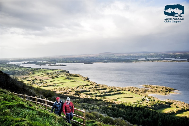
The initial part of the walk takes you across the top of the Magho Cliffs offering great panoramic views of the surrounding area. To continue the walk return back along the cliff top path and follow the black route way markers which will bring you down the cliff twisting and winding its way through the woodland with patches of open area providing great glimpses at the cliff escarpment. Lough Navar Forest is part of the Marble Arch Caves Global Geopark.
TRAIL INFORMATION
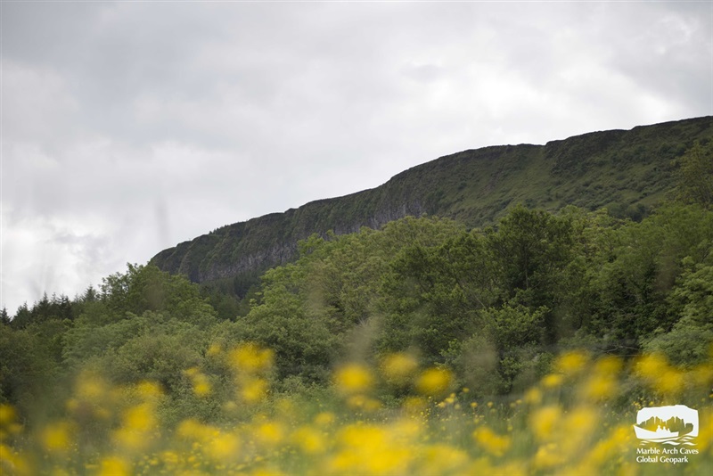
The initial part of the walk takes you across the top of the Magho Cliffs offering great panoramic views of the surrounding area. At the end of this path take a moment to rest on the bench provided and soak in the tranquil atmosphere. The cliffs are an Area of Special Scientific Interest as they support an exceptional range of habitats and the abundance of wildlife is very evident, keep an eye out for the array of butterflies and birds feeding in the area. To continue the walk return back along the cliff top path and follow the black route way markers which will bring you down the cliff twisting and winding its way through the woodland with patches of open area providing great glimpses at the cliff escarpment. The escarpment consists of three distinct rock formations. On top is the Dartry Limestone, the same rock that the Marble Arch Caves are formed out of, and directly beneath that is the Glencar Limestone. At the very bottom of the cliff, obscured from view by scree and vegetation is the Benbulben Shale, the oldest of the three rocks. The distinctive cliffs and present day landscape are a direct result of the last glaciation, which ended around 13,000 years ago, when huge ice sheets moved across the landscape scouring out valleys and sculpting the cliffs. The lower slopes are covered by one of the largest semi-natural woodlands in Northern Ireland which is very diverse and contains the highest number of woodland species recorded at a single site. Rare species within the wood include the bird’s nest orchid and early purple orchid. This walk is situated in a working forest and may be subject to temporary diversion and closure. In such circumstances, please ensure that all safety signage is complied with. All Forest Service NI woodlands are sustainably managed and certified against international standards that demonstrate good environmental, social and economic principles.
TRAIL INFORMATION
The initial part of the walk takes you across the top of the Magho Cliffs offering great panoramic views of the surrounding area. At the end of this path take a moment to rest on the bench provided and soak in the tranquil atmosphere. The cliffs are an Area of Special Scientific Interest as they support an exceptional range of habitats and the abundance of wildlife is very evident, keep an eye out for the array of butterflies and birds feeding in the area. To continue the walk return back along the cliff top path and follow the black route way markers which will bring you down the cliff twisting and winding its way through the woodland with patches of open area providing great glimpses at the cliff escarpment. The escarpment consists of three distinct rock formations. On top is the Dartry Limestone, the same rock that the Marble Arch Caves are formed out of, and directly beneath that is the Glencar Limestone. At the very bottom of the cliff, obscured from view by scree and vegetation is the Benbulben Shale, the oldest of the three rocks. The distinctive cliffs and present day landscape are a direct result of the last glaciation, which ended around 13,000 years ago, when huge ice sheets moved across the landscape scouring out valleys and sculpting the cliffs. The lower slopes are covered by one of the largest semi-natural woodlands in Northern Ireland which is very diverse and contains the highest number of woodland species recorded at a single site. Rare species within the wood include the bird’s nest orchid and early purple orchid. This walk is situated in a working forest and may be subject to temporary diversion and closure. In such circumstances, please ensure that all safety signage is complied with. All Forest Service NI woodlands are sustainably managed and certified against international standards that demonstrate good environmental, social and economic principles.
GETTING TO THE START
- Point of Interest The Magho Cliffs are a 9km long limestone escarpment dominating the southern shore and skyline of Lower Lough Erne on the northern edge of Lough Navar Forest. The 300 metre high cliffs command immense views to over the lake and neighbouring counties
- Facilities Toilets at the bottom of the cliffs. Picnic benches available on site. Nearest amenities in Derrygonnelly.
- Getting to the Start From Enniskillen take the A46 to Derrygonnelly and then follow the signs for the 'Forest Drive'.
- Public Transport Translink – journeyplanner.translink.co.uk
- Level of Difficulty
 Moderate TRAIL GRADE DISCLAIMER
 The trail grades shown on OutmoreNI.com and WalkNI.com are based on desk-based assessments of available trail information. The categories—Easy, Moderate, Strenuous, and Very Strenuous—follow the Sustainable Trails Development Guide grading system.
These grades are provided as a general guide to help users choose trails that may be suitable for them. They are not a substitute for official, on-site grading or safety information provided by the relevant land manager, which may differ from the information on these websites.
Outdoor activities involve inherent risks, including the risk of injury, death, property damage, and other hazards. By using information from OutmoreNI.com and WalkNI.com, you acknowledge that you do so at your own risk. OutmoreNI.com and WalkNI.com accept no responsibility or liability for any loss, injury, or damage arising from the use of this information.
Conditions on trails can change, and the actual environment may differ from what is described online. Users should always exercise their own judgment, take appropriate precautions, and remain responsible for their own safety and conduct at all times.
All information provided on OutmoreNI.com and WalkNI.com is intended as a guide only and should be used alongside your own experience, awareness, and careful decision-making.
Moderately challenging trails of varying widths with some short, steep climbs and descents. The surface may vary throughout, be slippery and uneven in places. Expect there to be obstacles like exposed roots, narrow gates, stiles and long sets of steps.
Outdoor clothing and sturdy footwear are recommended.