0.7 miles
Loop
Magilligan Point
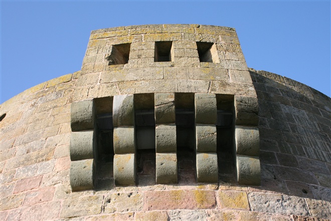
Magilligan Point guards the mouth of Lough Foyle and is home to Lough Foyle Ferry and Martello Tower.
This short beach walk through a National Nature Reserve provides opportunities for visitors to explore the beach or spot birdlife and sealife.
Please note pedestrian access only to this beach.
TRAIL INFORMATION
Arriving at Magilligan Point follow the road past the Point Bar leading to a car park adjacent to the boundary of Magilligan Nature Reserve. Park on the left hand side of the road and then pass through the kissing gate to view the Martello Tower straight ahead.
Pass to the right of the Tower through the dune land to meet with the beach near a military sangar. Turn left and continue along the beach as you round the Point with Lough Foyle opening up and the Ferry slipway coming into view. Retrace your steps along the beach and then return to the kissing gate via the Martello Tower.
Please be careful when using the steps as they are suffering from coastal erosion and can be uneven in places.
Access to the military firing range is restricted. Retrace your steps along the beach or through the duneland to view the Martello Tower.
Please refer to the downloadable leaflet on this webpage for opening times at Martello Tower.
GETTING TO THE START
- Point of Interest Martello Tower - built to stop French Invasion
- Facilities Toilets available at the Ferry terminal. Refreshments at Point Bar next to beach.
- Dog Policy Dogs must be kept under close control
- Accessibility Information
Accessibility Grade: Grade 5 Terrain: Sandy beach backed by duneland Toilet Facility: No Signage: No - Getting to the Start The beach is located at the end of Point Rd. Follow signs from the A2 for Lough Ferry. Use the car park opposite the Ferry Terminal or at Martello Tower. Access beach via steps adjacent to the Point Bar.
- Public Transport Translink – journeyplanner.translink.co.uk