2 miles
Loop
Moderate
Orlock Point
The Rocky outcrops of Orlock Point contain a mosaic of semi-natural habitats which support a rich diversity of plants and animals. The walk affords stunning views of the Copeland Islands and out across the Irish Sea towards Scotland. The area is steeped in archaeology and history, with evidence of Vikings, smugglers and World War II defences.
TRAIL INFORMATION
From the car park, the walk commences through the stile bearing the National Trust emblem. Walk along the path until you encounter a stony sheltered bay, crossing over the small stream (the Portavo River) with the standing stone to your left. A flight of steps leads up onto the headland and a large expanse of open farmland. While catching your breath, enjoy the views of the Copelands with the Galloway coast, Mull of Kintyre and Ailsa Craig providing a hazy backdrop. Take a moment to look for farmland birds feeding in the cereal fields or birds of prey hunting along the field margins.
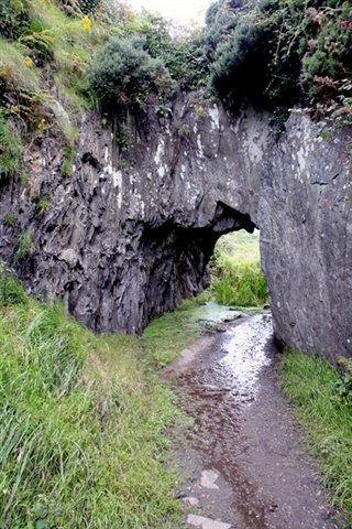
Continue on this path, along the top of the slope, through a stone stile. After another 200 yards, the path divides in two. The lower route will take you down towards the sea and onto the nineteenth century Orlock Coach Road for a short section. If you want flatter terrain, remain on the top path until they merge again a little further along. The path will then lead you down some more steps before passing under an archway which was hewn out of the rock by hand as part of the Coach Road. Chisel marks are still evident in places.
The path leads past some open shingle bays and sheltered coves. The Second World War lookout hut makes a good vantage point for watching passing seabirds and boat traffic. The walk ends at Sandeel Bay. At this point you can retrace your steps or continue up Sandeel lane to the main road and back to the start point.
This walk has been developed and maintained by The National Trust.
TRAIL INFORMATION
From the car park, the walk commences through the stile bearing the National Trust emblem. Walk along the path until you encounter a stony sheltered bay, crossing over the small stream (the Portavo River) with the standing stone to your left. A flight of steps leads up onto the headland and a large expanse of open farmland. While catching your breath, enjoy the views of the Copelands with the Galloway coast, Mull of Kintyre and Ailsa Craig providing a hazy backdrop. Take a moment to look for farmland birds feeding in the cereal fields or birds of prey hunting along the field margins.
Continue on this path, along the top of the slope, through a stone stile. After another 200 yards, the path divides in two. The lower route will take you down towards the sea and onto the nineteenth century Orlock Coach Road for a short section. If you want flatter terrain, remain on the top path until they merge again a little further along. The path will then lead you down some more steps before passing under an archway which was hewn out of the rock by hand as part of the Coach Road. Chisel marks are still evident in places.
The path leads past some open shingle bays and sheltered coves. The Second World War lookout hut makes a good vantage point for watching passing seabirds and boat traffic. The walk ends at Sandeel Bay. At this point you can retrace your steps or continue up Sandeel lane to the main road and back to the start point.
This walk has been developed and maintained by The National Trust.
GETTING TO THE START
- Point of Interest Orlock Point, The Copeland Islands, Orlock Farm
- Facilities There are no shops or toilet facilities on site. There are a number of shops, cafes restaurants and toilet facilities in Donaghadee and Groomsport.
- Dog Policy Dogs must be kept under close control
- Accessibility Information
Accessibility Grade: Grade 5 Terrain: Rocky Coastal Path Toilet Facility: No Signage: No - Getting to the Start Access is off the Donaghadee road, about 1.5 miles East of Groomsport and 2 miles North West of Donaghadee. Coming from Groomsport, pass the entrance to Orlock Road on your left and then look for the small left hand turn as the sea comes in to view.
- Public Transport Translink – journeyplanner.translink.co.uk
- Level of Difficulty
 Moderate TRAIL GRADE DISCLAIMER
 The trail grades shown on OutmoreNI.com and WalkNI.com are based on desk-based assessments of available trail information. The categories—Easy, Moderate, Strenuous, and Very Strenuous—follow the Sustainable Trails Development Guide grading system.
These grades are provided as a general guide to help users choose trails that may be suitable for them. They are not a substitute for official, on-site grading or safety information provided by the relevant land manager, which may differ from the information on these websites.
Outdoor activities involve inherent risks, including the risk of injury, death, property damage, and other hazards. By using information from OutmoreNI.com and WalkNI.com, you acknowledge that you do so at your own risk. OutmoreNI.com and WalkNI.com accept no responsibility or liability for any loss, injury, or damage arising from the use of this information.
Conditions on trails can change, and the actual environment may differ from what is described online. Users should always exercise their own judgment, take appropriate precautions, and remain responsible for their own safety and conduct at all times.
All information provided on OutmoreNI.com and WalkNI.com is intended as a guide only and should be used alongside your own experience, awareness, and careful decision-making.
Moderately challenging trails of varying widths with some short, steep climbs and descents. The surface may vary throughout, be slippery and uneven in places. Expect there to be obstacles like exposed roots, narrow gates, stiles and long sets of steps.
Outdoor clothing and sturdy footwear are recommended.