1.8 miles
Linear
Moderate
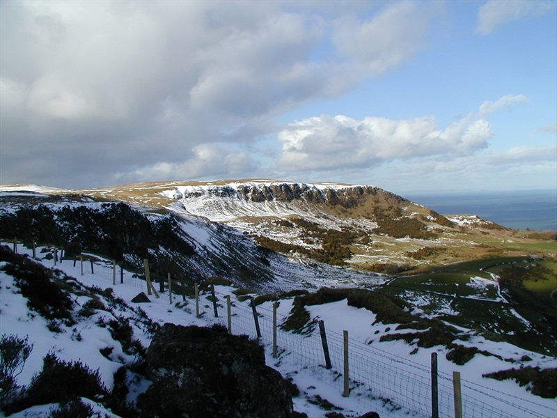
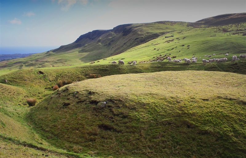
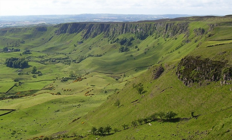
Sallagh Braes
A stunning short walk across exposed hillside, leading to and along the edge of the Sallagh Braes basalt cliffs. Views can be enjoyed across the cliffs to the valley below and the Irish sea in the distance. The local area has recently been featured in the popular tv series 'Game of Thrones', interpreation can be found in Linford Car Park and is a popular stop off point for fans of the show.
TRAIL INFORMATION
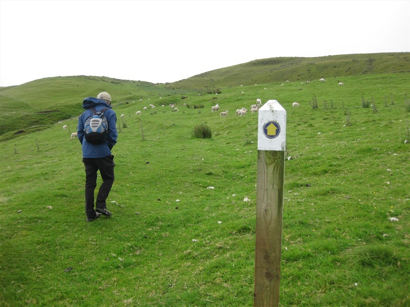
Leave Linford Car Park, using the style on the southern boundary of the car park. Follow the yellow and blue waymarkers for the Ulster Way/ Antrim Hills Way. Follow the desire line uphill towards the next fenceline. Pass over the shoulder of Robin Young’s Hill, and descend to heather moorland at the edge of Sallagh Braes.
Follow a fence around the rim of the escarpment, with steep gullies allowing an occasional glimpse into the void below. The airy sensation and the view over the curving cliffs make this a very memorable piece of walking. When the route starts to veer away from the edge of the escarpment, turn and retrace your steps back to the car park.
The Ballygally area is home to several areas of filming for the popular tv show 'Game of Thrones'. Cairncastle is a meadow area up from the main village of Ballygally, but there is no castle. This is where the cult series kicked off in its now trademark dramatic fashion, with Ned Stark beheading a Night’s Watch deserter in full view of Jon Snow, Theon Greyjoy and the Stark brothers Robb and Bran in Season 1.
In Seasons 4 1 and 5 Cairncastle was used as a location for The Neck. Cairncastle, which is high up on the Antrim plateau appears in the scene where Littlefinger took Sansa to Moat Cailin and she made her decision to ally with the Boltons. This dramatic plain with its basalt outcrops was chosen to represent The Neck, which is the backdrop to where Sansa learns she is now betrothed to the horrific Ramsay Bolton.
Sallagh Braes is the scenic location where Brother Ray built a Septry with the help of the Hound.
TRAIL INFORMATION
Leave Linford Car Park, using the style on the southern boundary of the car park. Follow the yellow and blue waymarkers for the Ulster Way/ Antrim Hills Way. Follow the desire line uphill towards the next fenceline. Pass over the shoulder of Robin Young’s Hill, and descend to heather moorland at the edge of Sallagh Braes.
Follow a fence around the rim of the escarpment, with steep gullies allowing an occasional glimpse into the void below. The airy sensation and the view over the curving cliffs make this a very memorable piece of walking. When the route starts to veer away from the edge of the escarpment, turn and retrace your steps back to the car park.
The Ballygally area is home to several areas of filming for the popular tv show 'Game of Thrones'. Cairncastle is a meadow area up from the main village of Ballygally, but there is no castle. This is where the cult series kicked off in its now trademark dramatic fashion, with Ned Stark beheading a Night’s Watch deserter in full view of Jon Snow, Theon Greyjoy and the Stark brothers Robb and Bran in Season 1.
In Seasons 4 1 and 5 Cairncastle was used as a location for The Neck. Cairncastle, which is high up on the Antrim plateau appears in the scene where Littlefinger took Sansa to Moat Cailin and she made her decision to ally with the Boltons. This dramatic plain with its basalt outcrops was chosen to represent The Neck, which is the backdrop to where Sansa learns she is now betrothed to the horrific Ramsay Bolton.
Sallagh Braes is the scenic location where Brother Ray built a Septry with the help of the Hound.
GETTING TO THE START
- Point of Interest Sallagh Braes cliffs, neolithic burial site, Linford barrels
- Facilities Car park
- Dog Policy Dogs are strictly not allowed, even when on a lead.
- Accessibility Information
Accessibility Grade: Grade 5 Terrain: Open hillside, grazed by sheep Toilet Facility: No Signage: No - Getting to the Start From Ballygalley, take the Cairncastle Road to Cairncastle. Turn right onto the Drumnagreagh Road, and left onto the Ballycoose Road after leaving the village. Continue on this road (which turns into Feystown Road) for 2 miles before turning left into Li
- Level of Difficulty
 Moderate TRAIL GRADE DISCLAIMER
 The trail grades shown on OutmoreNI.com and WalkNI.com are based on desk-based assessments of available trail information. The categories—Easy, Moderate, Strenuous, and Very Strenuous—follow the Sustainable Trails Development Guide grading system.
These grades are provided as a general guide to help users choose trails that may be suitable for them. They are not a substitute for official, on-site grading or safety information provided by the relevant land manager, which may differ from the information on these websites.
Outdoor activities involve inherent risks, including the risk of injury, death, property damage, and other hazards. By using information from OutmoreNI.com and WalkNI.com, you acknowledge that you do so at your own risk. OutmoreNI.com and WalkNI.com accept no responsibility or liability for any loss, injury, or damage arising from the use of this information.
Conditions on trails can change, and the actual environment may differ from what is described online. Users should always exercise their own judgment, take appropriate precautions, and remain responsible for their own safety and conduct at all times.
All information provided on OutmoreNI.com and WalkNI.com is intended as a guide only and should be used alongside your own experience, awareness, and careful decision-making.
Moderately challenging trails of varying widths with some short, steep climbs and descents. The surface may vary throughout, be slippery and uneven in places. Expect there to be obstacles like exposed roots, narrow gates, stiles and long sets of steps.
Outdoor clothing and sturdy footwear are recommended.