8.7 miles
Loop
Strenuous
Slieve Gullion
A mountain walk exploring the Slieve Gullion Special Area of Conservation and the Ring of Gullion Area of Outstanding Natural Beauty (AONB) using mountain paths, forest trails and country roads.
The walk is located within the Ring of Gullion Area of Outstanding Natural Beauty (AONB). The AONB is an area of national landscape importance and is centred on the craggy heather covered hills of a circular ring dyke volcano that erupted over 50 million years ago. The Ring of Gullion is the most famous ring dyke in the world having featured in geological debate and theory over the past 160 years.
Slieve Gullion rising to 573m is the centrepiece of the volcanic landscape and is a Special Area of Conservation (SAC) which recognises the importance of the geology and the upland heather moorland. The purples of the heather contrast with the yellow of dwarf gorse and orange of the bracken to create rich mosaics of colours which contrast with the many greens of the agricultural ladder farm landscape.
At the base of the mountains are a network of lowland loughs associated with a diversity of fen, bog and wetland vegetation including bulrush, cotton grass, bilberry and deciduous woodland.
People have lived in the Ring of Gullion for over 6,000 years. The area is renowned for the wealth of Megalithic and early Christian monuments including over twenty large stone tombs. Also close by is the Dorsey, dating from the Iron Age period. This is a massive earth embankment and rampart which sits astride an ancient routeway to Eamhain Macha, the ancient capital of Ulster.
The Ring of Gullion and Slieve Gullion, in particular, have rich associations with Irish legends and myths. In one tale, Finn McCool was bewitched by Miluchra on the summit of Slieve Gullion at the Lough of the Calliagh Bhirra. To this day the superstition survives that if you bathe in the lough your hair will turn white.
TRAIL INFORMATION
The walk starts and finishes in the car park adjacent to the Slieve Gullion Courtyard Centre in Slieve Gullion Forest Park. Follow the path uphill fromthe car park, passing the childrens play area on your left. The path continues uphill through deciduous woodland for about 1km until arriving at a log bench opposite a Ring of Gullion Way marker post. Turn right on to the forest drive and continue uphill through a stand of mature beech trees for 800m. Turn right on to a short section of forest track until the upper forest drive is reached. Turn left on the forest drive and continue along the southern slopes of Slieve Gullion for about 2km until an upper car parking area is reached on the left hand side. This section of the trail has magnificent views of the Ring of Gullion peaks of Croslieve, Slievebrack and Mullaghbane Mountain. In the upper parking area are interpretation panels that explain the geology of the area and provide further walking information on the Ring of Gullion Way.
Turn right fifty metres beyond the parking area up an initially steep mountain path. Continue on over a stile until a stone shelter is reached. The views in this section expand to include the peaks of Slievenacapple and the Ring of Gullion to the North. An interpretation panel at the stone shelter illustrates the legends associated with the area and the legendary Finn McCool.
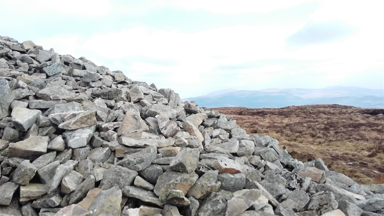
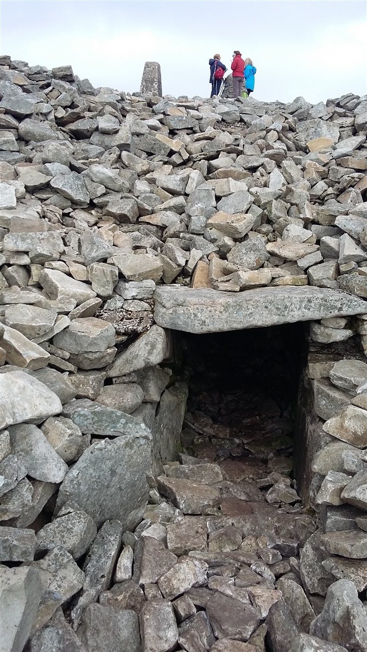
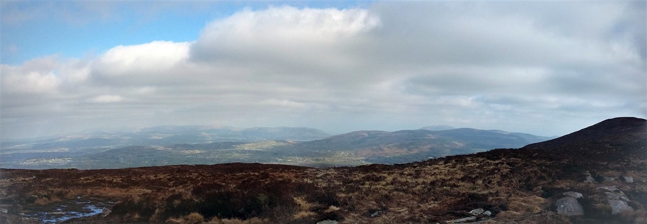
Passing to the right of the stone shelter the path becomes steeper, traversing areas of peaty and rocky ground. After 500m the path arrives at the summit of Slieve Gullion and the Neolithic South Cairn Passage Grave. The tomb can be entered from just below the summit. Panoramic views from the summit take in the Mourne Mountains, Carlingford Lough, The Cooley Peninsula, the Armagh Drumlins and beyond.
The path continues North-West along the summit plateau arriving at Calliagh Berras Lough after 800m. Continue past the lough to the North Cairn which is also a Bronze Age burial chamber. Veer right after passing the North Cairn and continue on the path. Descend for about 2km down the North side of the mountain until reaching the Ballard Road. Turn right along the country lane and follow it as it undulates through the countryside. Keep right after 2km where the road forks and continue to Killevy Old Churches an ancient convent dating from the 5th Century. St Moninna is buried in the churchyard. St Bline’s Holy Well is on the hillside above.
Continue along the country lane, past Clonlum South Cairn Portal Tomb on the left and Killevy Castle on the right for a further 2km before turning right at a cross roads. Continue through gateposts on to the exit drive from the courtyard centre and the car park.
Please note that this walk is in an upland enviroment, where it may not be appropriate to install waymarkers. Walkers should come prepared with an OSNI map and compass, as visibiliy in all weathers cannot be guaranteed at the top of the mountain. These walks are situated in a working forest environment and may be subject to diversion and closure from time to time.
Up to date information is available on the Forest Service web site - link below.
TRAIL INFORMATION
The walk starts and finishes in the car park adjacent to the Slieve Gullion Courtyard Centre in Slieve Gullion Forest Park. Follow the path uphill fromthe car park, passing the childrens play area on your left. The path continues uphill through deciduous woodland for about 1km until arriving at a log bench opposite a Ring of Gullion Way marker post. Turn right on to the forest drive and continue uphill through a stand of mature beech trees for 800m. Turn right on to a short section of forest track until the upper forest drive is reached. Turn left on the forest drive and continue along the southern slopes of Slieve Gullion for about 2km until an upper car parking area is reached on the left hand side. This section of the trail has magnificent views of the Ring of Gullion peaks of Croslieve, Slievebrack and Mullaghbane Mountain. In the upper parking area are interpretation panels that explain the geology of the area and provide further walking information on the Ring of Gullion Way.
Turn right fifty metres beyond the parking area up an initially steep mountain path. Continue on over a stile until a stone shelter is reached. The views in this section expand to include the peaks of Slievenacapple and the Ring of Gullion to the North. An interpretation panel at the stone shelter illustrates the legends associated with the area and the legendary Finn McCool.
Passing to the right of the stone shelter the path becomes steeper, traversing areas of peaty and rocky ground. After 500m the path arrives at the summit of Slieve Gullion and the Neolithic South Cairn Passage Grave. The tomb can be entered from just below the summit. Panoramic views from the summit take in the Mourne Mountains, Carlingford Lough, The Cooley Peninsula, the Armagh Drumlins and beyond.
The path continues North-West along the summit plateau arriving at Calliagh Berras Lough after 800m. Continue past the lough to the North Cairn which is also a Bronze Age burial chamber. Veer right after passing the North Cairn and continue on the path. Descend for about 2km down the North side of the mountain until reaching the Ballard Road. Turn right along the country lane and follow it as it undulates through the countryside. Keep right after 2km where the road forks and continue to Killevy Old Churches an ancient convent dating from the 5th Century. St Moninna is buried in the churchyard. St Bline’s Holy Well is on the hillside above.
Continue along the country lane, past Clonlum South Cairn Portal Tomb on the left and Killevy Castle on the right for a further 2km before turning right at a cross roads. Continue through gateposts on to the exit drive from the courtyard centre and the car park.
Please note that this walk is in an upland enviroment, where it may not be appropriate to install waymarkers. Walkers should come prepared with an OSNI map and compass, as visibiliy in all weathers cannot be guaranteed at the top of the mountain. These walks are situated in a working forest environment and may be subject to diversion and closure from time to time.
Up to date information is available on the Forest Service web site - link below.
GETTING TO THE START
- Point of Interest Cairns, Chambered Grave, Killeavy Castle and Killeavy Churches
- Facilities Car parking at the Slieve Gullion Courtyard. Village shops in Meigh, Drumintee and Forkhill sell supplies for taking on the walk and for having a picnic. Good food can be had in the restaurant or bar at Murphys in Meigh. The Forge Bar, Larkins and th
- Dog Policy Dogs must be kept under close control
- Accessibility Information
Accessibility Grade: Grade 5 Terrain: Minor roads and forest tracks Toilet Facility: No Signage: No - Getting to the Start From Newry take the Dublin Road until the Cloghoge Roundabout (2km). Travel on the B113 towards Forkhill, for approximately 5km past Meigh until the sign for Slieve Gullion Forest Park on the right hand side of the road just before Drumintee. Follow th
- Level of Difficulty
 Strenuous TRAIL GRADE DISCLAIMER
 The trail grades shown on OutmoreNI.com and WalkNI.com are based on desk-based assessments of available trail information. The categories—Easy, Moderate, Strenuous, and Very Strenuous—follow the Sustainable Trails Development Guide grading system.
These grades are provided as a general guide to help users choose trails that may be suitable for them. They are not a substitute for official, on-site grading or safety information provided by the relevant land manager, which may differ from the information on these websites.
Outdoor activities involve inherent risks, including the risk of injury, death, property damage, and other hazards. By using information from OutmoreNI.com and WalkNI.com, you acknowledge that you do so at your own risk. OutmoreNI.com and WalkNI.com accept no responsibility or liability for any loss, injury, or damage arising from the use of this information.
Conditions on trails can change, and the actual environment may differ from what is described online. Users should always exercise their own judgment, take appropriate precautions, and remain responsible for their own safety and conduct at all times.
All information provided on OutmoreNI.com and WalkNI.com is intended as a guide only and should be used alongside your own experience, awareness, and careful decision-making.
Physically demanding, narrow trails with steep climbs and descents over short and long distances. Expect the surface to be uneven and changeable throughout with natural surfaces like grass, exposed rock and trodden earth. The surface may change suddenly and be unstable in places. There will be slippery sections when wet and large, frequent obstacles like exposed roots, large boulders, overgrown sections, uneven stiles and long stretches of uneven steps.
Outdoor clothing and sturdy footwear are recommended.