10.3 miles
Loop
The Cranfield / Greencastle Route
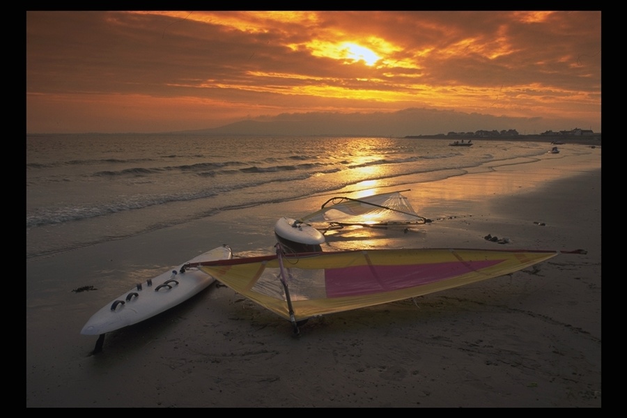
A gentle cycle mainly on the flat taking in an award winning Cranfield Beach (Blue Flag), an Anglo-Norman Castle, the ruins of a Norman Church, an Old Irish Ferry Pier and other interesting Points of Interest.
TRAIL INFORMATION
Head west out of the Square straight across the traffic lights onto Greencastle Street, you pass the Kilmorey Arms Hotel on your left. Keep to this road, it takes you through the townland of Dunnaval. After about 2 miles note the large house on your left called Eastwood, shortly afterwards the road divides. Take the right fork and proceed to a T-junction, turn right. Note the many sunken fields, which are old sand extractions (high quality building sand), restored to agricultural and recreational use.
At the next junction turn left to pass Grange School and Chapel on your left. The road now meanders through the marshy flood plain of the Whitewater River.
You come to a staggered crossroads, turn left. About a mile straight ahead is the Blue Flag Beach of Cranfield. However, your route turns immediately right following the directions to Greencastle about 1.7 miles.
The quiet seaside hamlet of Greencastle offers peace, tranquility and several interesting features: A notable Anglo-Norman castle built circa 1260; the ruins of the Old Norman Church; the Old Irish Ferry Pier; a row of fine coastguard and lighthouse keepers houses and the Irish Lights Base at the north quay which services all the navigation lights in Carlingford Lough and further south (including the picturesque Haulbowline Lighthouse). The hamlet offers magnificent views of Mill Bay, the Eastern Mournes, Carlingford Lough and across the water, Greenore and Carlingford on the Cooley peninsula.
Retrace your route back to Greencastle crossroads and turn left to cross the old bridge over the Whitewater River (a fine game fish river). The reed marshes on your left are a nature reserve for wild fowl and are known locally as the 'Bents'. Further along the route you come to Mill Bay with fine views up Carlingford Lough.
This is a migratory wildfowl wintering area of international importance. A little further along your route turns right onto the Corcreighan Road taking you through a typical 'Mourne' rural landscape of drumlins backed by the mountains. Continue along the Corcreighan Road crossing the Whitewater River once again and up Chesney's Brae to the Ballyardle crossroads. This was originally the main road from Kilkeel to Newry and was also the Mail Coach route. At the crossroads, note the old watering trough in the stable yard wall of 'Packolet'. Packolet was the home of General Francis Rawdon Chesney, the discoverer and surveyor of the route of the Suez Canal. On your right is the old Trollope post office, now unfortunately closed.
Turn left onto the Ballyardle Road and then after 150 metres, at the fork, turn right onto the Belmont Road. At the end of the Belmont Road turn left onto the Newry Road and then turn right onto the Drumcro Road. Follow the Drumcroe Road past Massforth Chapel on your right. The Giant's Grave is a Neolithic court grave found at the back of the graveyard. The directions to it are found on the Newry road towards Kilkeel at the Parochial House. There is a Rath beside the Chapel in the graveyard on the Drumcro Road. At the end of the Drumcro Road there is a junction, turn right onto the Mountain Road (the Burial Banks are on the right) and follow it back to the Lower Square in Kilkeel Town Centre.
GETTING TO THE START
The Lower Square is situated in the centre of Kilkeel Town where there is also a car park.
- Facilities You can purchase refreshments before leaving in Kilkeel. There are toilets also situated in the Square which is the starting point.
- Getting to the Start The Lower Square is situated in the centre of Kilkeel Town where there is also a car park.
- Traffic Information You will find some of roads will be quite busy as they are the only roads accessible to caravan sites at Cranfield so therefore you will encounter cars and perhaps some touring caravans during the summer season.
- Bike Hire Providers Life Adventure Centre Castlewellan Life Adventure Centre Grange Courtyard Forest Park Castlewellan Email: iwant@onegreatadventure.com Phone: +44 (0)2843770714 http://www.onegreatadventure.com
- Accessible Facilities It is a clear route with no obstacles although some of the country roads can be quite busy at times.